Date: 2003/7/20
Time: ~6:00 UT (2:00 a.m. EDT) to ~8:00 UT (4:00 a.m. EDT)
Location: Camp Site 52 in western Perry County, PA
Coordinates: 40°20'43.4" north, 77°33'43.7" west
Elevation: 482 meters
Transparency: 8/10
Seeing: 5/10
Instrument: 101mm f/5.4 Tele Vue Genesis sdf refractor
Oculars: 7mm Nagler type 6 with 2.5x Tele Vue Powermate (193x), 3-6mm
Nagler zoom (90 to 180x)
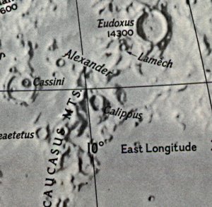
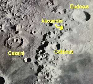
While observing Luna on Sunday morning, I noted what may be an unreported lunar light ray, and a triple one at that, in the moderately large walled plain Alexander (Rukl #13 - see http://www.astrosurf.com/cidadao/crater_alexander_01.jpg for an image). The narrow central ray was the longest. The two flanking rays were also narrow triangles. The visual effect of the three rays was striking and seemed almost gothic in appearance.
At the time that this was taking place my friend Tony Donnangelo and I were also viewing three other craters in which rays that were taking place through his 14.5" Starmaster Sky Tracker Dobnewt.
The triple ray in Alexander was still progressing nicely when I turned in for the night. An image of Alexander is available at http://www.astrosurf.com/cidadao/crater_alexander_01.jpg
Dave Mitsky
Harrisburg, PA
Site Longitude = +77.562
Site Latitude = +40.345
Site Elevation = +482.000

Feature = ALEXANDER
Feature Longitude: = +13.500
Feature  Latitude: = +40.300

Reproducing Lighting For: 2003/7/20 at 07:00 U.T.

Desired Solar Altitude =  +2.141(Setting),  Azimuth = +269.997
Average Co-longitude =  163.692
In the Time column, D=Daylight, T=Twilight

                      ---- Moon's ----    -- Earth's --
                        Topocentric        Topocentric      -------- Sun's --------
   UT Date    Time     Alt°   Semi-Diam''  Long°   Lat°     Colong°     Lat°    Azim°

 2003/07/20  07:00   +30.965    904.45    +4.341  +5.137    164.865   +1.383  +269.997
Alexander - +180, +645: A ring 60 miles across, with many signs of erosion in the past. The walls are low - mere hills, on the west, and the floor is dark with riges, hill and small craters. A high mountain exists on the north wall, while on the eastern part of the rampart are projections enclosing shallow rings. There are several landslips from the rampart, which is here somewhat pointed. The largest of these landslips is crescent-shaped, and includes two craterlets. - Wilkins and Moore, The Moon, Faber & Faber, 1955