Archimedes Ray (as reported by Bill Arnett)
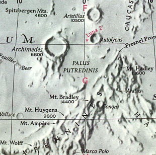
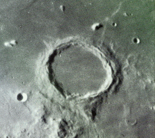
Early morning of 7/27/97: As soon as Luna rose above the trees, I noticed a nice shadow show on the floor of the crater Archimedes. (Archimedes is just east (lunar) of Dave North's favorite crater, Timocharis :) See chart 21 for a picture of Archimedes and Timocharis. As the Sun sank lower, the shadows filled Archimedes except for a bright ray which took about 2 hours to fade. For a while, Archimedes looked just like a letter theta. Then the ray faded into a tiny dash and disappeared. It takes a long time for these events to play out on the Moon, since it rotates so slowly (compared to Earth). At the end, I was using averted vision to hold the last tiny bit of it. Averted vision on the Moon -- who woulda thunk it?
The event took place on the morning of July 27th, 1997 (already 27th UT date). The time wasn't given, but in email correspondence will Bill, it was determined the moon rose at 1:00am PDT on that date. 1:00am PDT is 8 hours UT. I set the time for 1 hour later to 9:00 hours UT (to compensate for "rising above the trees). This ray needs to be re-examined to determine a more accurate time frame. It is suggested that when observing this ray, that one starts about 1 hour BEFORE the predicted time, to see if the event is progressing earlier that predicted. Using Bill's approximate coordinates, and the date and time selected, the predictions show the sun altitude was 1.628 setting:
Site Longitude = +122.200
Site Latitude = +37.400
Site Elevation = +100.000

Feature = archimedes
Feature Longitude: =  -4.000
Feature  Latitude: = +29.700

Reproducing Lighting For: 1997/7/27 at 09:00 U.T.

Desired Solar Altitude =  +1.628(Setting),  Azimuth = +267.796
Average Co-longitude =  182.126
In the Time column, D=Daylight, T=Twilight

                      ---- Moon's ----    -- Earth's --
                        Topocentric        Topocentric      -------- Sun's --------
   UT Date    Time     Alt°   Semi-Diam''  Long°   Lat°     Colong°     Lat°    Azim°

 1997/07/27  09:00   +12.546    951.24    +6.519  +6.007    181.494   -1.107  +267.796
The largest of the ringed plains on the Mare Imbrium, with broad, very complex walls averaging 4,200 feet but bearing several towers, rising to a maximum height of 7,400 feet....extending south and south west, is a disturbed region, covered with bright little mountains and including several curved ridges, evidently the relics of once complete rings. This region is traversed by a system of clefts, the majority of which run parallel to each other, al tending to the south-west and connecting with the long clefts running parallel to the main crest of the Appenines. - Wilkins and Moore, The Moon, Faber and Faber, 1955