Observers: Tony Donnangelo
Date/time of observation: 2003/08/19 06:07 U.T.
Site location: Tuscarora State Forest, PA, USA
Site coordinates: N. 40.51° W. 77.63°
Site elevation: 427 meters (1402 feet)
Site classification: State forest wilderness area
Instrument: 14.5” Starmaster Dob.
Magnifications: 267x, 351x, 373x, 522x
Moon's age: 20d 23:13, Illuminated: 57.4%
Librations: lat. +01°28’, long. +00°53’, PA -14.6°
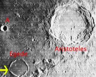
Object: Egede (crater)
Crater size: 37x37km (22x22mi) Height: 420m (1300ft)
Height/Wide ratio: 0.0114
Lunar ray coordinates: 10.0°E., 48.5°N.
Rukl chart #: 5
It was a very clear night. Transparency was good most of the night but did vary at times. Dew started as soon as the sun set and became very heavy. Mars and Saturn appeared very good. At 06:00 U.T., Dave Mitsky and I were able to see sections of the rille in Vallis Alpes. By 06:30 U.T., seeing became very steady and lighting conditions became more favorable; that enabled us to see the rille along its whole length using 373x. Higher magnifications were detrimental in seeing it better.
At 06:07 U.T. while observing Vallis Alpes, I noticed a narrow beam of light extending across the entire length of Egede’s floor. The very flat, smooth floor gave the ray an appearance of being very smooth and unbroken. The ray may have been visible some time earlier. The rim of the crater and western exterior wall were illuminated. The remainder of the crater was totally dark, except for the ray. At 07:00 U.T., the ray appeared the same. By 07:40 U.T., the sun set sufficiently for the ray to disappear
The Initial Predictions, Using Data in Original Reporting
Site Longitude = +77.630
Site Latitude = +40.510
Site Elevation = +427.000

Reproducing Lighting For: 2003/8/19 at 06:07 U.T.

Desired Solar Altitude =  +0.151(Setting),  Azimuth = +272.201

Feature = egede
Feature Longitude: = +10.600
Feature  Latitude: = +48.700

Average Co-longitude =  169.171

Moon's Altitude Restricted = Y Altitude =  +5.000 degrees

In the Time column, D=Daylight, T=Twilight

                      ---- Moon's ----    -- Earth's --
                        Topocentric        Topocentric      -------- Sun's --------
   UT Date    Time     Alt°   Semi-Diam''  Long°   Lat°     Colong°     Lat°    Azim°

 2003/08/19  06:07   +30.336    893.16    +0.943  +1.500    170.954   +1.566  +272.201
Description of crater from Virtual Moon Atlas: Formed during Lower Imbrian Period (From -3.85 billions years to -3.8 billions years). Circular formation. Little steep slopes. Little high walls. Flat floor filled with somber lava. Craterlets.