Hall Lunar Light Ray
Initial Reports
Observer: Tony Donnangelo
Date/time of observation: 2003/03/08 00:07 U.T.
Site location: Hummelstown RD 3, PA, USA (40.26Ḟ N., 76.75Ḟ W.)
Site elevation: 479 feet (146 meters)
Site classification: Suburban
Instrument: Takahashi FS-102
Magnification: 158x, 234x, 316x
Moon's age: 4d 21:31, 20.6% illuminated
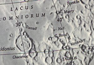
Object: Hall (crater)
Size: 39Km.x39Km. Height: 1140m.
Lunar ray coordinates: 37.25ḞE., 33.75ḞN.
Rukl chart #: 15
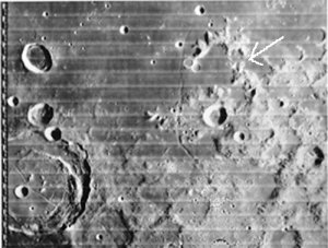
The crater's rim and area outside of the eastern wall were completely illuminated, whereas, the northern and western walls of the crater cast a shadow onto Lacus Somniorum. The crater's floor and interior walls were in total shadow, except for the sunrise ray. Rima G. Bond was within the diffuse area of the terminator and was only partially visible.
The ray appeared as a thin shaft of light extending ~55 Km. from a break in the crater's eastern wall, through the opening in the disintegrated portion of the western wall, across Rima G. Bond, and onto Lacus Somniorum. The ray was visible when I first started to observe, so would have begun some time earlier.
An illuminated peak within the crater, near the eastern wall, looked circular and slightly wider than the eastern end of the ray. The shadowed western wall of this formation formed a thin break in the illumination between the peak and the ray. The illuminated peak and the shadow of this wall made the ray look like a dotted i.
Within 15 minutes, the ray began to widen into a cone shape. As it continued to widen, the ray began to look comet-like with the illuminated peak being the coma. It continued to widen steadily, and, by 01:00 U.T., the ray was wider than the opening in the disintegrated western wall. This again formed another interesting sight. The sections of the western interior wall of the crater, directly adjacent to each side of the opening in the wall, were now illuminated, and the opening in the wall caused the ray to be narrower beyond the crater than what was seen within its interior.
I last observed the ray at 01:30 U.T., as the moon went behind a tree. By this time, the ray was unrecognizable as such. The floor of the crater was now mostly illuminated, except for the northern most area. It was cold out and time to warm up, with everything frosting over.
The Initial Predictions, Using Data in Original Reporting
Site Longitude = +76.750
Site Latitude = +40.260
Site Elevation = +146.000
Feature =
Feature Longitude: = +37.250
Feature Latitude: = +33.750
Reproducing Lighting For: 2003/3/8 at 00:07 U.T.
Desired Solar Altitude = +1.776(Rising), Azimuth = +93.032
Average Co-longitude = 324.886
In the Time column, D=Daylight, T=Twilight
---- Moon's ---- -- Earth's --
Topocentric Topocentric -------- Sun's --------
UT Date Time AltḞ Semi-Diam'' LongḞ LatḞ ColongḞ LatḞ AzimḞ
2003/03/08 00:07T +38.033 892.96 -2.332 +2.770 325.912 -1.532 +93.032
Crater Description:
Description from Virtual Moon Atlas: Wrecked formation. Pretty steep slopes. Walls dismantled to the west. Flat floor filled with lava closed by Rima G. Bond to the west.
Return to Home or use your browser back button