Initial Reports
Observer: Larry B. Smith
Date/Time: 1-9-03/18:28 EDT (23:28UT)
Location: Mt. Joy Twp., Pa.
Site Elevation: ~130 ft. AMSL
Sky Darkness: 1st quarter moon, 43%
Instrument: 12.5-inch, D & G Optical, Dobsonian
Magnification: 100X and 200X
Weather: partly cloudy (cirrus clouds), 34 F, light wind
Seeing: good when no clouds
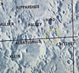
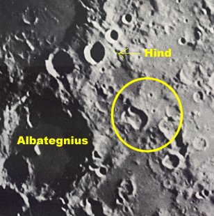
Object: Lunar sunrise ray at 9.5 deg. south and Lat and 9.2 deg. east (Rukl Chart #45)
The location is an unnamed depression or crater approximately 50 km SE of the crater Hind. The ray extended from the break in the mountainous area towards the west for ~ 45km.
The Initial Predictions, Using Data in Original Reporting
Since the region for this ray is in an area devoid of named features, the ray will be referenced with Hind, although the ray was reported 50km SE. The actual predictions though will be generated using the coordinates that were listed. Hind's longitude is +7.4deg and latitude is -7.9deg (from NASA database of 6,000 near side craters). Area in question is +9.2deg longitude and -9.5deg latitude
Site Longitude = +75.800
Site Latitude = +40.100


Feature =
Feature Longitude: =  +9.200
Feature  Latitude: =  -9.500

Reproducing Lighting For: 2003/1/9 at 23:28 U.T.

Desired Solar Altitude =  +1.593(Rising),  Azimuth = +90.802
Average Co-longitude =  352.415
Crater Description:
There is no ideal description for this area.
Return to Home or use your browser back button