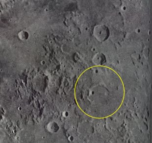
Lade Sunset Ray
Initial Reports
Date/Time: 1-24-03/06:29 EST (11:29UT)
Location: Mt. Joy Twp., Pa.
Site Elevation: ~130 ft. AMSL
Sky Darkness: waning gibbous moon (21 days 4.5 hours), 59%.
Instrument: 12.5-inch, D & G Optical Dobsonian
Magnification: 200X
Weather: clear, 6 F, light wind with moderate gusts.
Seeing: good to very good.
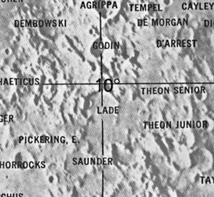
Object: Lunar sunset ray located at lat. 1.2 deg. south and long. 10 deg. east (Rukl Chart #45).
The sunset ray extended towards the E-SE from near the center of the crater s. The southern portion of the ray s distal end was just to the north of the small crater that s located on Lade s SE wall. By 07:31 the Lade ray had disappeared, but Lilius was still cone shaped.
The Initial Predictions, Using Data in Original Reporting
Starting Date = 2003/1/1 at 00:00 U.T.


Feature = Lade
Feature Longitude: = +10.100
Feature  Latitude: =  -1.300

Reproducing Lighting For: 2003/1/24 at 11:29 U.T.

Desired Solar Altitude =  +1.681(Setting),  Azimuth = +268.081
Average Co-longitude =  168.219
Crater Description:
Lade: +172,-020; A large partial formation to the south of Godin; of the former wall only the northern portion now remains. On the interior is a nearly central crater, while on the north-east is the fine crater A; and along the northern floor, close to the wall, a craterlet row. The west wall end in a sharp promontory. To the south of the crater A are isolated hills, the site of an ancient ring. On the east, beyond the valley, is another fragment of the wall, while on the outer north is a crater, B. On the north-est is a crater, C, and some craterlet rows, together with many obscure rings.(Wilkins & Moore, The Moon, 1955, Faber & Faber Ltd.)
Return to Home or use your browser back button