Observer: Larry B. Smith
Date/Time: 1-24-03/06:29 EST (11:29UT)
Location: Mt. Joy Twp., Pa.
Site Elevation: ~130 ft. AMSL
Sky Darkness: waning gibbous moon (21 days 4.5 hours), 59%.
Instrument: 12.5-inch, D & G Optical Dobsonian
Magnification: 200X
Weather: clear, 6 F, light steady wind with some gusts.
Seeing: good to very good.
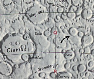
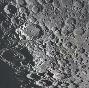
Object: Lunar sunset ray located at 54.4 deg. south lat. and 6.4 deg. east long. (Rukl Chart #73). The relatively short and narrow, cone-shaped sunset ray originated from Lilius central floor peak and projected approximately 20 km to the eastern wall.
The UT date and time used for the initial circumstances is Jan 24, 2003 @ 11:29UT (6:29 am EST). The solar altitude at that time was +.429 setting with a colongitude of 166.418 degrees
Feature = lilius
Feature Longitude: =  +6.200
Feature  Latitude: = -54.500

Reproducing Lighting For: 2003/1/24 at 11:29 U.T.

Desired Solar Altitude =  +4.279(Setting),  Azimuth = +273.772
Average Co-longitude =  166.418
Lilius: +063,-814; A fine ringed plain 32 miles in diameter, with steep and finely terraced walls, especially on the inner slopes. These are disturbed by a crater on the east and by the Ring A, on the west. This has disturbed a crater on its west wall and has some small craters on its floor. On the interior of Lilius is a fine, steel central mountain with two lower hills...(Wilkins and Moore, The Moon, 1955, Faber & Faber Ltd.)