Lubiniezky E Lunar Light Ray
Initial Reports
Observer: Tony Donnangelo
Date/time of observation: 2003/03/13 00:40 U.T.
Site location: Hummelstown RD 3, PA, USA (40.26° N., 76.75° W.)
Site elevation: 479 feet (146 meters)
Site classification: Suburban
Instrument: Takahashi FS-102
Magnification: 158x(5.2mm Pentax XL), 234x(3.5mm Orion Lanthinum SW)
Moon's age: 9d 22:04, 67% illuminated
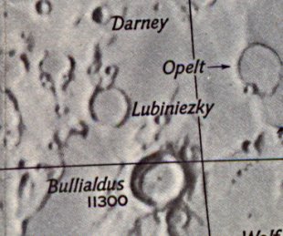
Object: Lubiniezky E (crater)
Size: ~40Km.x~40Km.
Lunar ray coordinates: 26.75°W., 16.75°S.
Rukl chart #: 53
The border of a cloud bank ran west to east at the zenith, making observing difficult. It was ~80 to 90% cloudy near the moon, totally cloudy to its south, and mostly clear to its north. I normally wouldn’t attempt observing under those conditions; however, I began observing an hour prior to a lunar ray prediction for Mercator, which I had never seen. With no ray yet occurring, I began observing other features. I noticed a possible ray in Lubiniezky E, but within a minute, clouds covered the moon. To confirm my sighting, I waited for more holes to appear. Surprisingly, when possible, seeing was very steady. I called Dave Mitsky and reported my observation. Living only a few miles away, he arrived within fifteen minutes. I also called The Astronomical Society of Harrisburg’s Naylor Observatory, located ~18 miles further south. Members present said it was totally cloudy with no observations possible.
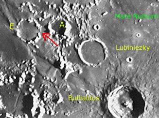
Crater Lubiniezky was prominently illuminated. The rim of craters Lubiniezky A and E were also illuminated. The segmented-like wall structure of crater E was evident, particularly on the western side. Crater E’s floor was in total shadow.
The ray appeared as a very narrow, very dim, shaft of light extending the full length of the crater floor through a visible opening in the eastern wall. The very flat, featureless floor gave the ray an interesting appearance of being very smooth and unbroken. The ray was visible when I first started to observe, so would have begun some time earlier.
Dave and I were able to observe the ray at 1:15 U.T. It now appeared slightly cone shaped and brighter. By 1:30 U.T., the crater’s floor was completely illuminated, except for the northern most area, and the ray was no longer recognizable. It may still have been detectible, only if you were aware of its previous existence. At 2:15 U.T., it became totally cloudy, and we ended our observing session.
The Initial Predictions, Using Data in Original Reporting
Site Longitude = +76.763
Site Latitude    = +40.281
Site Elevation  = +146.000

Reproducing Lighting For: 2003/3/13 at 00:40 U.T.

Desired Solar Altitude =  +0.752(Rising),  Azimuth = +91.307
Feature =  Lubiniezky E
Feature Longitude: = -26.750
Feature  Latitude:   = -16.750

In the Time column, D=Daylight, T=Twilight

                      ---- Moon's ----    -- Earth's --
                        Topocentric        Topocentric      -------- Sun's --------
   UT Date    Time     Alt°   Semi-Diam''  Long°   Lat°     Colong°     Lat°    Azim°
 2003/03/13  00:40T  +75.845    934.78    -7.263  -3.912    027.094   -1.468  +91.307
Crater Description:
Description: I have no published description of this crater. To me, it appears to have a lava flooded, flat, and featureless floor; a considerably disintegrated wall with low steep slopes.
Return to Home or use your browser back button