Observer: Tony Donnangelo
Date/time of observation: 2003/01/22 08:00 U.T.
Site location: Hummelstown RD 3, PA, USA (40.27° N., 76.75° W.)
Site elevation: 362 feet (110 meters)
Site classification: Suburban
Moon’s age: 19d 11:36, 82% illuminated
Libration: N/S -6.71; E/W -1.29
Instrument: Takahashi FS-102
Magnification: 91x (9mm Nagler T6), 158x (Pentax 5.2mm XL)
234x (3.5mm Vixen SW)
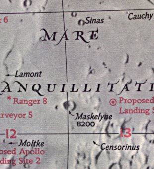
Object: Mare Tranquillitatis east of Maskelyne P
Lunar ray coordinates: 00.5°N., 35.5°E.
Rukl chart #: 36
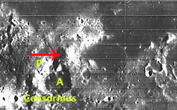
I believe that crater P is associated with the crater Maskelyne. The crater walls of P and A appear rather high. The Lunar Orbiter photographic plate, IV-073-H1, shows a distinct, very high mountain peak east and adjacent to P. The height of this peak was quit evident when I was viewing the ray. These craters and the peak caused the floor of the mare, in this flat cove-like area, to be completely shadowed.
I had a hard time recognizing the proper location of the ray. I was somewhat confused because of the lighting conditions on the surface. Most of the area was shadowed, and I’ll fortuitously blame it on the extremely bitter-cold weather that I had been exposed to, since early evening. It was one of the few clear nights we had this winter, and I wanted to take advantage of it. I was in a state of exhaustion and planned on going to bed, until I spotted the ray. It can be oriented by scanning southeast of easily seen Maskelyne and directly south of craters Aryabhata and F, which are easily observed as U-shaped structures on the mare floor. Craters A and P were visible, but heavily shadowed beyond their west rim.
The ray emanated, from just north of the high peak. The Lunar Orbiter photograph shows what appears to be a notch in this area. The ray stretched east onto the floor of the mare. It was a thin shaft of light that fanned out into a very slight cone shape. I roughly estimated that it was about 1 1/2 degrees long. Remember, though, that my body was, by now, frozen harder than the ice cubes in my freezer.
I observed it for 1 1/2 hours. It maintained its shape, but became progressively shorter during the last thirty minutes. When I last looked at it, it was less than half its original length, with the east section still visible. It may have been visible at an earlier time.
Site Longitude = +76.750
Site Latitude = +40.270
Site Elevation = +110.000

Reproducing Lighting For: 2003/1/22 at 08:00 U.T.

Desired Solar Altitude =  +3.692(Setting),  Azimuth = +268.710

Feature = MASKELYNE P
Feature Longitude: = +34.100
Feature  Latitude: =  +0.500

Average Co-longitude =  142.208

Moon's Altitude Restricted = Y Altitude =  +5.000 degrees

In the Time column, D=Daylight, T=Twilight

                      ---- Moon's ----    -- Earth's --
                        Topocentric        Topocentric      -------- Sun's --------
   UT Date    Time     Alt°   Semi-Diam''  Long°   Lat°     Colong°     Lat°    Azim°

 2003/01/22  08:00   +56.159    983.61    -1.724  -5.920    142.196   -1.255  +268.710
NO DESCRIPTION