Observer: Tony Donnangelo Date/time of observation: 2004/03/03 03:15 U.T. Site location: Hummelstown RD 3, PA, USA (40.26° N., 76.75° W.) Site elevation: 479 feet (146 meters) Site classification: Suburban Moons age: 11d 05:56, 84.8% illuminated Libration: 8.1°, PA: 144° (-6° 04 in Lat., -4° 32 in Long.) Instrument: Takahashi FS-102 f/8 Magnification: 234x Object: Mersenius P (crater) Lunar ray coordinates: 19.5° S, 47.0° W Rükl chart #: 51
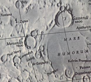
I found no published description for the crater Mersenius P. It lies between, and abuts Mersenius northeast rim and crater Ss southwest rim.
I started observing at 00:05 U.T. The sky was fair. There were thin, high, cirrus clouds causing a halo around the moon. Seeing was steady. It was chilly in the low 40s and high 30s with no dew. Approximately two hours later, I was joined by Dave Mitsky.
We were observing various interesting objects and shadows on the moon when I noticed a very thin shaft of light, approximately 25 Km. long, in Mersenius P. The eastern exterior wall of Mersenius was illuminated, with the remainder of the crater shadowed. Crater Ss rim and exterior was illuminated, while its floor remained shadowed. Mersenius Ps rim and eastern exterior wall was illuminated, as was the upper section of its western interior wall. Its floor was completely shadowed, except for the ray.
The ray emanated from a break in the northeast section of the wall. The ray stretched west across the northern section of the crater to the interior base of the western rim. There was a thin shadow running north to south cutting the ray approximately in half. The shadow appeared to be caused by a raised area on the floor. That made it look interesting, since there doesnt appear to be anything obvious there.
The ray may have been visible some time earlier, but not much. Observing that area earlier revealed no ray. Within twenty minutes, the ray broadened slightly. It remained as such until the moon set behind a tree at 05:00 U.T. The floor of the crater, at that time, was still completely shadowed except for the ray.
The Initial Predictions, Using Data in Original Reporting
Site Longitude = +76.750
Site Latitude = +40.260


Reproducing Lighting For: 2004/3/3 at 03:15 U.T.

Desired Solar Altitude =  +1.036(Rising),  Azimuth = +91.093

Feature = MERSENIUS P
Feature Longitude: = -47.800
Feature  Latitude: = -19.900

Average Co-longitude =  48.902

Moon's Altitude Restricted = N

In the Time column, D=Daylight, T=Twilight

                      ---- Moon's ----    -- Earth's --
                        Topocentric        Topocentric      -------- Sun's --------
   UT Date    Time     Alt°   Semi-Diam''  Long°   Lat°     Colong°     Lat°    Azim°

 2004/03/03  03:15   +71.577    917.73    -4.494  -6.059    048.402   -1.380  +91.093
Crater Description:
Mersenius, -709,-368: A great formation 45 miles in diameter, with fine terraced walls, rising 7,000 feet on the west but still higher on the north, where the wall is broken through be valleys. The south wall is also cut by valleys, and just beyond the south-east crest is the crater H. Here the crest is broad, and has three craters on the outer slope. On the convex interior of Mersenius is a nearly central craterlet, one of a chain from the south wall. From three craterlets on the west wall, a cleft crosses the floor near the central craterlet. Along th inner west is a cleft, passing through a craterlet near the foot of the wall and sending out a branch to the north component of a short craterlet-chain.There is also a short cleft near the south rampart. On the south glacis is a ring with a craterlet on its north rim; to the east is another crater, from which two clefts run eastwards for about 5 miles and then joins craterlet chain which traverse the floor from north to south. East of this are two more clefts, traceable as far as a crater south of H. AS cleft runs from the north wall of Mersenius as far as Letronne. The north wall of Mersenius itself is peculiar, as it is prolonged northwards, and there is a crater chain developing into a cleft and running as far as the crater F. To the west of this crater chain and toward sthe cleft already described is yet another cledt, starting at a hill and ending at a craterlet near a small mountain mass. The the east Wilkins, using a 12-1/2 inch reflector, on 18 November 1923, found a cleft skirting the east wall and running south-east.(Wilkins and Moore, The Moon, Faber and Faber, 1955)