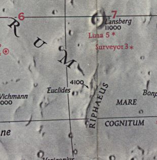
On the night of Friday, May 28, 2004, I observed a previously unreported lunar light ray in Montes Riphaeus, a 150 kilometer long mountain range that lies south of the crater Lansberg. I noticed the ray initially sometime around 9:30 EDT (01:30 UT 2004/5/29) while scanning the terminator at 159x with the 12.5" f/6.5 Cave Newtonian at the Astronomical Society of Harrisburg's Naylor Observatory (position: 40.1° N, 76.9° W; elevation: 190 meters), which is located 2 miles northwest of Lewisberry, Pennsylvania. A bit later I verified my sighting with the ASH 17" f/15 classical Cassegrain, employing magnifications of 162, 202, and 259x. What I saw was a thin shaft of light running westward to the terminator, just south of an arc-shaped region in the Riphaeus Mountains. The ray was positioned roughly at 6.25° south, 27.5° west.
At 10:45 EDT (02:45 UT), just prior to leaving the observatory, I noted that the ray had widened somewhat.
My friend Tony Donnangelo was observing from his home that night and was able to confirm my sighting.
Dave Mitsky=======================================
Observer: Tony Donnangelo Date/time of observation: 2004/05/29 02:30 U.T. Site location: Hummelstown RD 3, PA, USA (40.26° N., 76.75° W.) Site elevation: 479 feet (146 meters) Site classification: Suburban Instrument: 14.5Starmaster dob. Magnification: 203x & 351x Object: Montes Riphaeus (Mountain chain)
It was partly cloudy with high thin clouds and haze. Seeing and transparency were extremely poor. The planets were not worth observing. The only thing that looked half-decent was the Moon.
I was attempting to locate some asteroids when Dave Mitsky called me from ASH Naylor Observatory at 02:30 U.T. He said he was observing a possible lunar ray. I quickly turned my scope back to the area he indicated, and indeed, I was able to see that it was a ray. I observed some features in that area earlier and saw no ray, so it would have started within the prior 35 minutes.
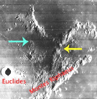
The ray was slightly cone shaped and ~ 31 Km. (13.4) long when I first observed it. It emanated from a break in the range (yellow arrow) and extended to a small rise to the west (green arrow)[see location photo at bottom - Rob]. In 30 minutes, it lengthened past the rise and widened to the north beyond the rise.
Seeing continued to get worse, and I ended my observing session at that time.
The Initial Predictions, Using Data in Original Reporting
Site Longitude = +76.900
Site Latitude = +40.100


Reproducing Lighting For: 2004/5/29 at 01:30 U.T.

Desired Solar Altitude =  +0.482(Rising),  Azimuth = +89.229

Feature = MONTES RIPHAEUS
Feature Longitude: = -28.100
Feature  Latitude: =  -7.700

Average Co-longitude =  28.586

Moon's Altitude Restricted = N

In the Time column, D=Daylight, T=Twilight

                      ---- Moon's ----    -- Earth's --
                        Topocentric        Topocentric      -------- Sun's --------
   UT Date    Time     Alt°   Semi-Diam''  Long°   Lat°     Colong°     Lat°    Azim°

 2004/05/29  01:30T  +51.939    958.83    -7.467  -3.926    028.681   +0.700  +89.229
Crater Description:
Riphaen Mountains, -464,-150: A small range of mountains consisting of a curved arc, concave to the southwest, with two low pieaks rising to nearly 3,000 feet...The whole range is bright and is evidently the relic of once-prominent ringed plains, now reduced to mere fragments by erosive forces. (Wilkins and Moore, The Moon, Faber & Faber, 1955)