PALLAS LUNAR LIGHT RAY
Initial Reports
Observer: Tony Donnangelo
Date/time of observation: 2003/03/11 01:40 U.T.
Site location: Hummelstown RD 3, PA, USA (40.26° N., 76.75° W.)
Site elevation: 479 feet (146 meters)
Site classification: Suburban
Instrument: Takahashi FS-102
Magnification: 158x, 315x, 394x using
5.2mm Pentax XL w/2x Barlow & 2.5x TV Powermate)
Moon's age: 7d 23:04, 48% illuminated
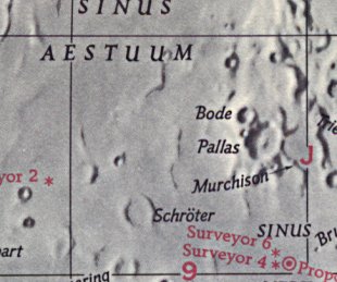
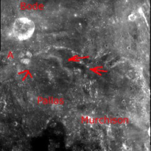
Object: Pallas (crater)
Size: 50Km.x50Km. Height: 1260 meters
Lunar ray coordinates: 01.00°W., 05.75°N.
Rukl chart #: 33
This evening presented one my best nights of seeing conditions so far this year. There were no clouds, haze, dew or frost, with seeing being very transparent and steady. It was another cold night, with the temperature about 20° F. The lunar features were stunningly sharp, allowing intricate detail to be seen. Rimae located in the area of craters Triesnecker and Hyginus, east of crater Pallas and Murchison, were exceptionally prevalent.
Pallas’ rim and central mountain peak were illuminated, with the interior of its western wall being especially bright. Except for the ray, its floor was completely shadowed.
The ray was visible when I first started to observe, so would have begun some time earlier. It appeared as a slightly cone-shaped shaft of light extending ~45 Km. from a break in the northern section of the crater wall between Pallas and Murchison. The ray ran north of the central mountain to the base of the wall below Pallas A, where the wall protrudes into the interior of Pallas. This structure was noticed in the western end of the ray. A thin shadow, running northwest to southeast, cut diagonally across the ray. This shadow, located almost at mid-point, was caused by a wrinkled ridge in the shape of the numeral 3. At this time, no detail or structure of the ridge was apparent, making the shadow’s cause unknown. The ray may be narrower if observed earlier.
I observed the ray occasionally, particularly due to warm-up breaks. By 3:00 U.T., the ray was slightly broader, the eastern wall of the central mountain was now illuminated, and the section of the wrinkled ridge, causing the shadow, was now evident. By 3:30 U.T., the ray broadened quickly, and most of the crater’s interior was illuminated.
The Initial Predictions, Using Data in Original Reporting
Site Longitude = +76.750
Site Latitude = +40.260
Site Elevation = +146.000

Feature =
Feature Longitude: =  -1.000
Feature  Latitude: =  +5.750

Reproducing Lighting For: 2003/3/11 at 01:40 U.T.

Desired Solar Altitude =  +2.095(Rising),  Azimuth = +91.716
Average Co-longitude =   3.106
In the Time column, D=Daylight, T=Twilight

                      ---- Moon's ----    -- Earth's --
                        Topocentric        Topocentric      -------- Sun's --------
   UT Date    Time     Alt°   Semi-Diam''  Long°   Lat°     Colong°     Lat°    Azim°
 2003/03/11  01:40   +52.691    908.98    -6.230  -1.366    003.257   -1.496  +91.716
Crater Description:
Description from Virtual Moon Atlas: Damaged circular formation. Forms an interesting couple with Murchison. Steep slopes supporting Bode to the North-West Pallas B & E to the South and crushed by Murchison to the East. Walls supporting the craterlet Pallas A to the North-West and Pallas H to the South. Flat floor filled with lava in communication to the North-East with that of Murchison. Central mountain. Hills, wrinkle ridges, and craterlets.
Return to Home or use your browser back button