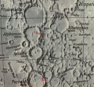
Observer: Dave Mitsky/Tony Donnangelo Date/time of observation: 2004/08/23 00:30 U.T. Site location: Cherry Springs State Park, Potter County, PA, USA Site coordinates: N. 41°39ĺ43.2ö (41.66199°) W. 77°49ĺ28.9ö (77.82470°) Site elevation: 707 meters (2,319 feet) Site classification: State park (isolated area) Instrument: 14.5ö Starmaster Dob. Magnification: 203x & 267x Moon's age: 6d 22:35 Illumination: 45.4% Apparent Dia.: 31.92ĺ Range: 374,334 Km. Librations: 4.4°, PA 63°, N/S 1.97°, E/W -3.92° Object: Parrot (crater) Dimensions: 70x70 Km. (43.5x43.5 Mi.) Height/Wide ratio: 0.0253 Lunar ray coordinates: 4.25°E, 14.0°S. Rükl chart #: 55
It was a year since we made the three hour and fifteen minute drive to this official state designated dark sky park set aside and maintained primarily for astronomy. The weather finally cooperated for two days to warrant the trip. It was a minor miracle for this year in Pennsylvania. Since the forecast changed abruptly, we only packed the essentials and made a late departure. This was our second night of observing.
We started observing at 00:00 U.T., seven minutes after sunset. The moon was at -21° 29ĺ declination, and appeared unsteady at times. It was not as clear as the previous night. The transparency was worse and there was some cloudiness. The field was much drier than the day before. There was very little dew until approximately 07:30 U.T., and ground fog became heavy at 08:00 U.T. (see the initial Sacrobosco ray report from the previous night).
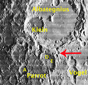
The ray was already underway when we noticed it at about 00:05 U.T. It may have been visible at an earlier time, but perhaps not much sooner. It was initially long and thin, extending approximately two-thirds across the craterĺs floor.
The floor of Parrot is heavily cratered, particularly in the northern half where the ray occurred. Some crests of these interior rims were illuminated. We also noticed illuminated areas that appeared, with uncertainty, to be a ray. It had a very broken appearance, and mingled across the illuminated peaks - a very interesting view and not a typical looking ray. As the ray began to fan out quickly, it grew more apparent. More of the interior craters and floor structure became visible. By 00:50 U.T., the ray had broadened considerably. About an hour later, at 01:40 U.T., it was very broad and pie-shaped. Most of the floor was illuminated and the ray was no longer recognizable as such.
The Initial Predictions, Using Data in Original Reporting
Site Longitude = +77.825
Site Latitude = +41.662
Site Elevation = +707.000

Reproducing Lighting For: 2004/8/23 at 00:30 U.T.

Desired Solar Altitude =  +1.937(Rising),  Azimuth = +88.060

Feature = parrot
Feature Longitude: =  +3.300
Feature  Latitude: = -14.500

Average Co-longitude =  358.701

Moon's Altitude Restricted = N

In the Time column, D=Daylight, T=Twilight

                      ---- Moon's ----    -- Earth's --
                        Topocentric        Topocentric      -------- Sun's --------
   UT Date    Time     Alt°   Semi-Diam''  Long°   Lat°     Colong°     Lat°    Azim°

 2004/08/23  00:30T  +21.989    974.42    -4.398  +3.214    359.062   +1.392  +88.060
Crater Description:
Description from Virtual Moon Atlas: Damaged and deformed circular formation situated on the south slope of Albategnius. Steep slopes supporting Parrot A to the southwest, Vogel to the east and riddled of craters to the north. High walls to the east disappeared to the west and ridden to the northwest by several craters. Tormented floor supporting a complex structure to the west.