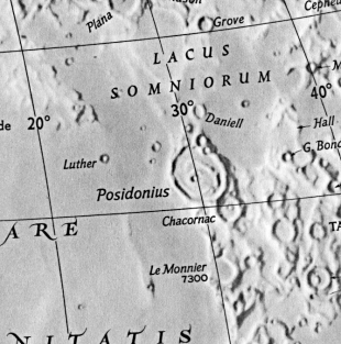
Observer: Dave Mitsky
Date/time of observation: 2002/1/18 23:35 UT
Location of site: ASH Naylor Observatory, 2 miles northwest
of Lewisberry, PA, USA (40.1° N, 76.9° W; elevation 190 meters)
Site classification: Exurban
Sky darkness: ~5.0 magnitude after moonset
Seeing: 6 <1-10 Seeing Scale (10 best)>
Instrument: 17" f/15 equatorially mounted classical Cassegrain
Magnification: 162, 202, 259x
Object: Posidonius

Last night while I was scanning the moon at 23:35 UT I happened to
notice what might be an unreported lunar sunrise ray in the large
crater Posidonius.  At that time the ray was a moderately broad swath
of light that illuminated the northern portion of the crater.  Crater
Posidonius A, which is located more or less centrally, was not
illuminated.  By 01:30 UT (2002/1/19) the ray had expanded enough to
light Posidonius A, which was by then casting a shadow towards the
western wall of Posidonius.  I continued to observe the ray until
sometime after 02:00 UT.  At that time most of the interior of the
crater was awash with light.

An image of Posidonius can be seen at
http://perso.club-internet.fr/legault/pos_m.jpg

Dave Mitsky
Harrisburg, PA
Using the above coordinates and observational data, the following ephemeris for the date and time shows the colongitude was 332.06°:
        Ephemeris For  2002/ 1/18 at 23:35 U.T.

Site Longitude:   76.900                             J.D. 2452293.48264
 Site Latitude:   40.100                       Sun's Alt. -16.10° (Twilight)
Site Elevation:  190 meters                   Moon's Alt.  34.66°

 Earth's Selen    Sun's Selen     Frac     ------- Topocentric -------
 Long     Lat    Colong   Lat     Illum    Phase    Distance  Semi-Dia   HP
  °        °        °      °               Angle°      kms        "       '
-2.10     6.79   332.06  -0.85    0.251    120.5   400,071.09   896.06  54.10


 -------- Moon's ---------      Perigee Date/       Apogee Date/  Anomalistic
    R.A.           Dec.           Parallax            Parallax       Phase
  0h  2m 50s    -5° 21' 22"   2002/ 1/30  9: 3    2002/ 1/18  8:51   0.519
                                   60.91'              54.07'
Moon's Age  P.A. of Axis
   (d)           °
   5.419      336.54
For the time and date in question, the parameters were:
Starting Date  = 2002 / 1 / 18  U.T.
Site Longitude =   76.90   Latitude =   40.10   Elevation =  190 meters
Feature = POSIDONIUS
Longitude =  29°54'  Latitude  =  31°48'
Reproducing Lighting For:  2002 / 1 / 18  at  23 : 35  UT
Desired Solar altitude =   1.215° (Rising),  Azimuth =  91.759°
Average Co-longitude = 331.530
For generating predictions, 1.215° rising was used for the desired solar altitude, with a targeted 331° of average co-longitude
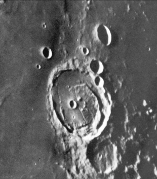
Posidonius +419,+526 - A majestic ring, 62 miles in diameter, with low and narrow walls, rising at their highest point 6,000 feet about the light interior and broad on the west, but especially narrow on the east, where they rapidly thin and end in a distinct break. On the surface, to the outer east, are little hills. On the interior, which has a peculiar glittering aspect, are the remains of an inner ring, well marked on the west by wanting in parts on the north and fragmentary on the south-east. On the interior of Posidonius, apart from this ring, is a nearly central crater. A, with a rough circle of hills on its west, doubtless the relic of a once perfect crater. There are smaller craters on the south, one of which Laméch declared to be subject to occasional obscuration in a manner similar to what Schröter found in connection with the great crater A. On the northern portion are numerous hills, craterlets and a low ring. On the north wall is the deep crater, T, with smaller craters, B and D, to the south. On the southern portion of the floor is a fine cleft, running east to west and easily seen, while other clefts exist; on the the crater A and some more delicate clefts intersecting on the west. Two clefts run northwards from A to a cleft tending east to west on the north, while a cleft cuts through the north wall and others divide the western rampart. To the southeast of Posidonius is a large, ancient ring, from the south-east of which a strong mountain ridge runs, in a somewhat serpentine fashion, southwards across the mare Serenitatis. This ridge rises, in places, to 800 feet and is very easily seen in small instruments. Along the outer north-west glacis are low rings and beyond, among other, the crater Giner. It is of some interst that the crater A is shown on the map of Riccioli (1651). Tobias Mayer depicts a central mountain, as he also did in the case of Archimedes, probably owing to the small aperture of his telescope. He was, also probably misled by the appearance under high illumination. The crater A was seen by Schröter and also Schmidt to be shadowless at times when it ought to have exhibited some.Dr. R. W. Porter, using the 60-in reflector of the Mt Wilson Observatory, found 11 July 1929, a rough circle of hills west of A, a cleft from north to south skirting the western side of A, which then bends west and passes betwee some hills on the southand ends at a portion of the inner ring. East of A was seen a long hill from which a cleft runs south to a minute craterlet. He also found a crater to the north-east of A, and five shallow clefts from the western part of the inner ring toward the rough circle of hills west of A. There was also a short branch cleft to the great cleft on the northern part of the interior, and many mounds or landswells. Of the craters connected with Posidonius, Arthur found that J has a hill on the southwest part of its floor and a ridge on the inner north and east. D.C. Brown, with a 10-inch telescope, found minute craterlets near Giner, which also contains two brilliant spots on its floor. He traced pits between Giner and Daniell. - Wilkins and Moore, The Moon, Faber & Faber, 1955.