Observer: Tony Donnangelo
Date/time of observation: 2003/12/03 03:45 U.T.
Site location: Hummelstown RD 3, PA, USA (40.26° N., 76.75° W.)
Site elevation: 479 feet (146 meters)
Site classification: Suburban
Moon’s age: 9d 04:45, 73.6% illuminated
Librations: 7.7° PA: 306° (4°54’ in Lat., 5°34’ in Long.)
Instrument: Takahashi FS-102 f/8
Magnification: 273x
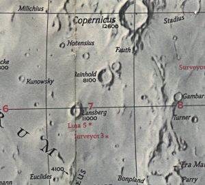
Object: Reinhold (East of)
Lunar ray coordinates: 2.5°N, 20.5°W
Rukl chart #: 31
I started my observing session at 01:00 U.T. The temperature was 29° with a wind-chill factor of 19°. It was clear and fairly transparent early in the evening. A few small cumulous clouds were moving through the area. By 04:45 U.T., sky conditions deteriorated. The moon was getting low in the west (setting time was 07:05 U.T.), and a fast moving, high, thin cloud layer caused a hazy appearance around the moon. By 06:15 U.T., I ended my lunar observations. It became cloudier, and the moon began setting behind a tree.
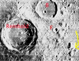
I was concentrating on observing a previously reported lunar light ray near Cichus A. I was also watching for rays predicted to occur at a later hour in Kies and Longomontanus. At 03:45 U.T., I observed a ray east of Reinhold. The ray may have begun some time earlier. The small mound to the east was illuminated and looked like a dot. The eastern walls of the other two mounds were also illuminated. The lower lying flat areas west of the three mounts were shadowed.
The ray was very thin throughout the time of its visible and was ~26 Km. long. It extended west over a flat area until it reached a raised formation. At 05:30 U.T., the area was almost completely illuminated and only a hint of the ray remained.
Reproducing Lighting For: 2003/12/3 at 03:45 U.T.

Desired Solar Altitude =  +1.439(Rising),  Azimuth = +90.623

Feature =
Feature Longitude: = -20.500
Feature  Latitude: =  +2.500

Average Co-longitude =  21.940

Moon's Altitude Restricted = N

In the Time column, D=Daylight, T=Twilight

                      ---- Moon's ----    -- Earth's --
                        Topocentric        Topocentric      -------- Sun's --------
   UT Date    Time     Alt°   Semi-Diam''  Long°   Lat°     Colong°     Lat°    Azim°

 2003/11/01  00:00T  +25.939    960.95    +7.022  +7.486    350.649   +0.333  +88.183
 2003/12/03  03:45   +46.356    912.64    +5.850  +4.995    021.965   -0.560  +90.623
The area south and east of Reinhold is rugged terrain. There are craterlets, ridges and many isolated mounds. The ray emanated from two of these mounts located ~2° (~60 Km.) east of the crest of the most southern part of Reinhold’s rim. Both mounds are slightly elongated north to south. They are also oriented north to south of each other. A slight gap between them was responsible for the ray. There is a smaller, rounder mound just east of the gap.