from Jane Houston Jones, September 18th, 1999 - time unknown
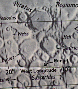
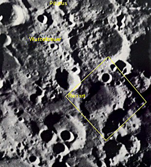
I took a glance at some nearby craters in the same field of view as Hesiodus, but a little to the south. What do you think I saw? Two more rays were making an appearance! I rushed to my Rukl to see what the crater was called. The crater is unnamed, but if you look on Rukl 64, you'll see what I mean. My twin rays were in the teartrop shaped feature to the the south and between Craters Wurzelbauer and Gauricus. Between 36 and 38 S and 16 and 14 W. The two slivers of light made a nice companion to Hesiodus to the north. As the hours passed, my twin slivers widened and became chunky triangles much like the Hesiodus Ray nearby. Later still, they merged into a "W" or "M" shaped feature, a beautiful contrast to the dark of the crater floor.
(webmaster's note: This is NOT an official IAU name for this crater ruin. In order to give a description to the area that Jane described I did some research on some older maps and books, and it was found that Wilkins & Moore designated this crater as Renart. Their description follows below.)
Since no time was given, but from the rest of the observing report, it was noted they were giving a public star party at Fremont Peak (121.32W, 36.48N). Therefore a time of 8:00pm PDT will be used. Follow up observations will be needed to see if this original sighting time needs to be adjusted. Converting to universal time we have the observation being taken on Sept 19th, 1999 @ 4:00 UT. By running predictions using site coordinates, date and time of the event, it was determined that the event could be seen when the sun was 1.024 degrees rising, with an average colongitude of 16.967 degrees. This data was used to compute the predictions, found on the prediction page.
Starting Date  = 1999 / 8 / 1  U.T.
Site Longitude =  121.32   Latitude =   36.48   Elevation =  122 meters
Feature = RENART
Longitude = -15°36'  Latitude  = -41°30'
Reproducing Lighting For:  1999 / 9 / 19  at  4 : 0  UT
Desired Solar altitude =   1.024° (Rising),  Azimuth =  87.638°
Average Co-longitude =  16.967
In the time column, D=daylight, T=twilight

                      ---- Moon's ----
                         Topocentric     -- Earth's --    ------- Sun's -------
   UT Date    Time     Alt°  Semi-diam"   long°   lat°    colong°   lat°   azim°
 1999/ 9/19   4: 0    31.39    907.53    -3.14   -3.51     17.93    1.09   87.64
Crater Description:
Renart, (no coordinates given): This lies partly within this section and partly within section VII (referring to their 300" map). It is a large ring south of Wurzelbauer, with a crater, A, on its north wall, a crater, F, on the east and craterlets and hills on its floor. - Wilkins and Moore, The Moon, Faber and Faber, 1955