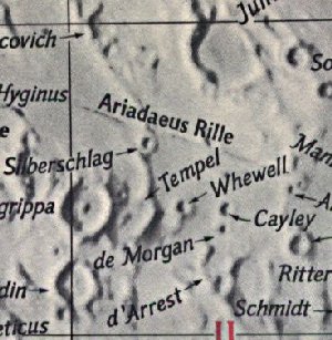
Observer: Tony Donnangelo
Date/time of observation: 2004/10/05 06:45 U.T.
Site location: Tuscarora State Forest, PA, USA
Site coordinates: N. 40.51° W. 77.63°
Site elevation:  427 meters (1402 feet)
Site classification: State forest wilderness area
Instrument: 14.5” Starmaster Dob.
Magnifications: 152x, 203x, 267x
Moon's age: 20d 16:15, Illuminated: 60.8%
Librations: 6.6°, PA 189°, N/S -6.49°, E/W +1.00°
Object: flat floor area between craters Tempel and d’Arrest
Lunar ray coordinates: 12.0°E, 2.5°N
Rukl chart #: 34
The location of this ray might be considered part of the Cayley Plains, which are connected to this area. The plains are light, smooth, and of uncertain origin.
I was setup before sunset. Unfortunately, it was completely cloudy until 03:00 U.T. (11:00 p.m. local time), when clearing commenced and the moon became visible within the tree line. Light dew started forming at nightfall and became very heavy by 06:30 U.T. I began observing the moon as it cleared the trees at 03:50 U.T. Seeing was very turbulent, but transparency was good.
I was previously observing a lunar ray in Alexander until 06:30 U.T. (see my report). I then turned to deep sky observing. Within twenty minutes, I began looking for a ray to occur in Lade at 09:31 U.T. Perhaps it might start earlier than predicted (see my report). I noticed a ray occurring south of Tempel. It was very thin and dim. I didn’t notice it when I was observing Alexander, but may have missed it. It may be visible earlier on. When is a good question for someone to answer.
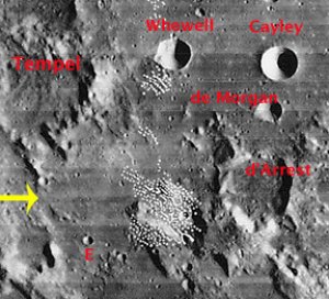
Tempel has a disintegrated wall. There is a ridge extending from its southern end into a flat plain. There is also an area of ridges east of crater Godin. There is a gap between the two ridge complexes. The ray emanated from this location and extended eastward toward craters Arrest and A. The eastern half of Tempel was within the terminator and may be hard to pinpoint. It would be easier locating the craters Godin and Agrippa.
By 07:20 U.T., the ray became extremely thin and dim. At 08:24 U.T., it completely disappeared. This ray may have a very narrow window to be observed.
During this time, don’t miss the opportunity to observe Rima Hyginus, Rimae Triesnecker, and the western section of Rima Ariadaeus. See why Rima Hyginus has the appearance that it may be rimless collapsed pits.
The Initial Predictions, Using Data in Original Reporting
Site Longitude = +77.630
Site Latitude = +40.510
Site Elevation = +427.000

Reproducing Lighting For: 2004/10/5 at 06:45 U.T.

Desired Solar Altitude =  +1.388(Setting),  Azimuth = +270.472

Feature =
Feature Longitude: = +12.000
Feature  Latitude: =  +2.500

Average Co-longitude =  166.610

Moon's Altitude Restricted = N

In the Time column, D=Daylight, T=Twilight

                      ---- Moon's ----    -- Earth's --
                        Topocentric        Topocentric      -------- Sun's --------
   UT Date    Time     Alt°   Semi-Diam''  Long°   Lat°     Colong°     Lat°    Azim°

 2004/10/05  06:45   +45.854    894.83    +1.235  -5.428    166.633   +0.532  +270.472
Crater Description:
TEMPLE, +206,+064: An imperfect ring south-east of Whewell, with broad slopes and a break on the north, On each segment either side of the break is a craterlet. Tempel stands on the rim of a large ancient ring crossed by a cleft. South is the relic of another old ring, of which the south wall is still rugged and lofty. South is a mountain mass, Delta, also some hills and small craters. (Wilkins and Moore, The Moon, Faber & Faber, 1955)