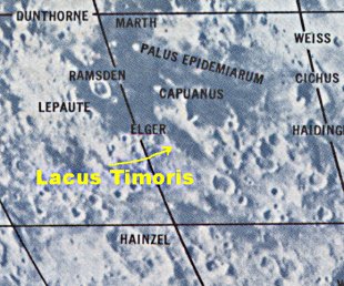
Lacus Timoris Sunrise Ray
Initial Reports
Observer: Larry B. Smith
Date/Time: 1-12-03/19:38 EST (1-13-03/00:38UT)
Location: Mt. Joy Twp., Pa.
Site Elevation: ~130 ft. AMSL
Sky Darkness: 1st quarter moon, 60%>
Instrument: 12.5-inch, D & G Optical, Dobsonian
Magnification: 177X
Weather: clear, light wind, 20 F
Seeing: very good with brief moments of excellent.
Object: Lacus Timoris lunar sunrise ray at 39.2  deg. south and Lat and 28.5 deg. west (Rukl Chart #63)
The ray extended 60 km to the west from the broken ridge, which divides Lacus Timoris, and ended on the western side of a horseshoe-shaped mountain that projects from the mare floor. The distal end of the ray was about 12 km wide. The eastern floor of Lacus Timoris was highlighted by sunlight, whereas, the western portion was dark with the exception of the ray.
The Initial Predictions, Using Data in Original Reporting
Site Longitude = +75.800
Site Latitude = +40.100


Feature = Lacus Timoris
Feature Longitude: = -28.500
Feature  Latitude: = -39.200

Reproducing Lighting For: 2003/1/13 at 00:38 U.T.

Desired Solar Altitude =  +1.303(Rising),  Azimuth = +90.348
Average Co-longitude =  30.181
Crater Description:
Lacus Timoris, no description of area
Return to Home or use your browser back button