*************************************************************************************************
From: Dave Mitsky
Subject: Walther Sunset Ray
Message:

Rob,
I just thought that I'd bring you to speed on the whole Walther/Walter thing in case you haven't heard. It seems that there's been some confusion about the true name of the crater Walther. Old lunar atlases, including the original Kalmbach Press Atlas of the Moon by Antonin Rukl, used the name Walter, which apparently was changed to Walther by the IAU in 1979. I was using the old Rukl atlas when I discovered the "Walter" Ray and the name on chart 65 was, of course, Walter.
http://en.wikipedia.org/wiki/Walther_(crater)
In summation, the name of the ray should be changed to the Walther Ray.
I'd like to add an amendment to my report at http://www.lunar-occultations.com/rlo/rays/walter.htm mentioning the fact that at the time that I discovered the ray this information was not widely known and I was going by what the Rukl atlas called the crater.
Initial Reports
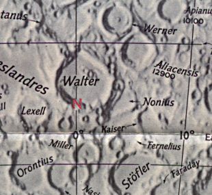
Observer: Tony Donnangelo Date/time of observation: 2004/02/28 02:40 U.T. Site location: Hummelstown RD 3, PA, USA (40.26° N., 76.75° W.) Site elevation: 479 feet (146 meters) Site classification: Suburban Moons age: 7d 05:21, 49.9% illuminated Libration: 2.7°, PA: 187° (-2° 29 in Lat., -0° 22 in Long.) Instrument: Takahashi FS-102 f/8 Magnification: 158x Object: Walter (walled plain) Dimensions: 132 Km. x 140 Km. / 80 Mi x 85 Mi. Lunar ray coordinates: 1.0° E, 33.5° S Rükl chart #: 65
I started observing at 23:45 U.T. The sky was mostly clear with breezy conditions. Seeing wasnt very steady. It was warm, in the high 40s, with no dew.
At 02:15 U.T., I took a break. When I returned, I noticed a long, slender beam of light in the crater Walter. Walters rim was illuminated. Its western wall abutted the terminator. The summit of the central peak was illuminated. The remainder of the floor was in shadow. I hadnt observed the ray earlier, so the time may be very close to its inception.
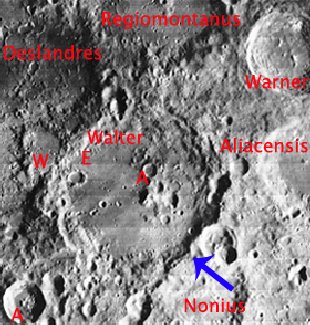
The ray began south of and at the same longitude as the central peak. It extended over crater E to the base of the western wall. It originated from a notch in the eastern wall. A north to south thin shadow bisected the ray. The shadow appeared to be caused by a low, round, domed feature that cast a slight shadow to its west. The dome feature may have been an illusion. There are several craterlets in that vicinity, and one of them may have been the cause of the shadow. A craterlets floor may have been illuminated, with its western rim casting the shadow. It would be interesting to observe this ray again, taking note of the floor area as the ray gets older.
Dave Mitsky arrived approximately 25 minutes later. He had discovered the Walter Sunset Ray, so it was fitting that he observed this one. By the time he arrived, the ray had already widened appreciably. A pointed shadow cast by a peak on the eastern rim of Walter now lay within the ray and extended approximately two-thirds of its length. We would have liked to make further observations of the floor area as the sun rose higher, but the moon set from our view before that was possible. The atmosphere also became much more turbulent closer to the horizon. We ended our observing session at 04:00 U.T.
The Initial Predictions, Using Data in Original Reporting
Site Longitude = +76.750
Site Latitude = +40.260


Reproducing Lighting For: 2004/2/28 at 02:40 U.T.

Desired Solar Altitude =  +0.912(Rising),  Azimuth = +91.113

Feature = WALTER
Feature Longitude: =  +0.700
Feature  Latitude: = -33.000

Average Co-longitude =   0.388

Moon's Altitude Restricted = N

In the Time column, D=Daylight, T=Twilight

                      ---- Moon's ----    -- Earth's --
                        Topocentric        Topocentric      -------- Sun's --------
   UT Date    Time     Alt°   Semi-Diam''  Long°   Lat°     Colong°     Lat°    Azim°

 2004/02/28  02:40   +42.090    894.43    -0.323  -2.475    359.459   -1.431  +91.113
Crater Description:
Description of Walter taken from the Virtual Moon Atlas website: It was formed during the Nectarian geological period (from 3.92 to 3.85 billion years ago). A circular formation with steep slopes supporting many craters with Nonius to the southeast, Walter C to the northwest, and Walter D & Nonius L to the east. It has very high walls with terraces, immense flat floor that contains Walter E to the west and a group of craters with Walter A to the northeast. Craterlets and lines of crests line the floor.